Temporary Closure of Beaches to Dogs
Beaches within the Parksville Qualicum Beach Wildlife Management Area (PQBWMA) will be temporarily closed to dogs to the annual Brant geese migration. Rathtrevor Beach will be closed to dogs from February 15 to April 30. Parksville Bay Beach and Qualicum Beach from March 1 to April 30.
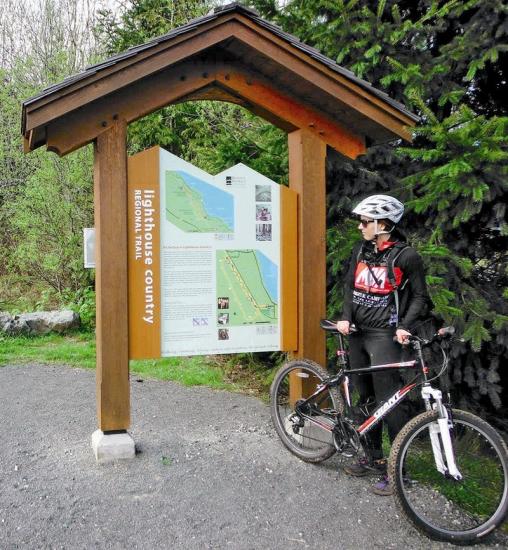
More InfoLighthouse Country Regional Trail
It's nice when the work of a community is recognized and augmented, especially when it leads to more people being able to enjoy an experience.
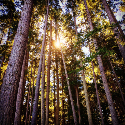
When trails are built right, they can be a valuable transport link or a literal and figurative pathway to health, nature, freedom and relaxation. In the case of The Lighthouse Country Regional Trail, the construction of the route strikes a cleverly conceived balance between widely inclusive accessibility and the feeling of being IN nature, rather than looking at it. The route, if completed as a loop, varies significantly in build technique but, irrespective of terrain or construction, is designated as a Regional Trail Corridor in all but one short section, which we will miss on this occasion. Around the whole trail development, surroundings are predominantly forest, but include woodlot (owned by the Wilson family), Crown Land, hydro cut, forest service road , river valley and, for much of the route, the edge of the dormant E&N Railway. We will only be covering the South Loop in this feature, but stay tuned for a description of the North loop and the trail used to link with it at a later date.
“ [Trails] can be a valuable transport link...to health, nature, freedom, and relaxation. ” Michael Addiscott
Heading West from the ample parking (complete with washrooms) just off Lions Way, you will quickly get a feel for the inclusive nature of this first section. Tightly compacted gravel makes for a predictable surface, suitable for walkers, runners, wheelchair users, strollers and leisure cyclists. All but the smallest, narrowest tyres will roll with relative ease, and the unpaved treatment given to the trail retains a slightly less urbanised feel. Another feature worth noting is the tap rail installed along the length of this flagship trail section, aiding access for those with vision impairment. A dead straight avenue of around 250 metres, edging the ballfield of Lion's Park brings us to a Northward turn at the crossing of the E&N Railway. Once through the staggered barriers, take careful note of the trailhead to your left. If you plan to complete a full loop, this is where you will re-join on your way out of the woods. For now, though, bear right across the first of many well constructed bridges that help to hold the trail above the soft ground and watercourses. Two of the bridges, to be crossed later, are remarkable in their appearance. Unlike the dozen or so wooden bridges which blend relatively well into their surroundings, these two, constructed from gleaming aluminium, look like they would be more at home in a marina. While doubtless well chosen for strength and durability, they look more than a little incongruous in this forest setting.
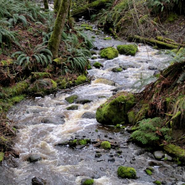
The wet nature of the surroundings have clearly required a massive investment in trailbuilding expertise and infrastructure. The result of this commitment to doing it right from the start is that less maintenance will be required. A walk through on a sunny Spring day lets you look deep into the heart of a lush, green forest, rich with dripping mosses, rotting stumps, draining marshes and towering second growth evergreens. Along with the bridges, countless culverts channel water beneath the trail, keeping it firm and dry. While the path would easily allow two bikes, strollers or wheelchairs to pass in opposite directions, it follows much of the high ground used by the original trailbuilders to minimize wetness so it twists and turns in a most attractive, but not very direct, way through the trees.
“ A walk on a sunny spring day lets you look deep into the heart of a lush, green forest, rich with dripping mosses, rotting stumps, draining marshes, and towering second-growth evergreens. ” Michael Addiscott
As the seasons change, the different odours of a damp forest rise from the ground, water and vegetation. Skunk cabbage is dominant just now, but changes in temperature lift other smells at different times of day along the route. It is actually rare to be in close and constant proximity to such a damp environment, as normally one would not have the luxury of being able to travel through marshes and across rivers in such comfort.
Keep eyes peeled, not only for interesting natural features, but also for some creative chainsaw work from the trailbuilders. Toadstools, faerie houses, animals and benches all await discovery at the side of the trail. After approximately 1300 metres, or 2/3 of the way along this outward leg, you'll find a good sized gravel “pull-out” to the side of the trail, complete with benches and a picnic table. This is an ideal spot to grab a snack, or to point out to kids as the intended lunch-stop on the return journey.
Judging distance is hard in such an environment, and perhaps that's a good thing as a walk in the woods should, where possible, be an escape from the pressures of time. For those interested in keeping track, another two hundred metres or so brings you to a driveway crossing. This allows a left turn to shorten the circular route by just over a kilometre.
One thing worth noting is that anyone relying on the high level of engineering seen on this first section will effectively be obliged to plan an “out and back” trip. Accessing the other sections of trail requires the ability to cover a total distance of around 5km on a mix of well made trail, logging road and twisty, rooty singletrack. For that reason, walkers, runners and reasonably competent off-road cyclists will be best suited to a circuit.
“ Keep your eyes peeled, not only for interesting natural features but also for some creative chainsaw work from the trail builders. ” Michael Addiscott
In most cases, people follow the gravelled trail to the end before choosing one of 3 options; Return by the same route on the fully manicured trail, cut through a mix of singletrack, damp hydro clearcut and river gully to access the rougher, North Loop (which we will cover in a later feature) or, as I am about to describe, swing West then South on the Nile Creek FSR. After the care with which the gravel trail was constructed, there's almost a feeling of culture shock coming out of the woods and following a road so comparatively lacking in aesthetic value. For many, a trip through the trees and clearcuts like this would deliver a sense of being in nature, but in this instance, it feels like nothing more than a utilitarian way of getting back to our start point. Happily, there is clear evidence of tree planting, alongside the inevitable falling, so hopefully a more natural feel will develop as the years pass. For many, this may be the closest they have come to active falling. The devastated clearings and piles of stripped tree trunks, although small by comparison to large operations, may bring home the impact such industry can have on areas which currently attract tourists and other leisure users.
It's almost a clear shot of 2 1/2km to the entrance to the flagged trailhead that will bring us back to our start-point. Only a driveway crossing and a couple of logging spurs intersect this main road. Keep following straight and eventually you'll encounter a distinct tunnel of trees. There will be flagging and a small RDN sign on your left (the sign was on the ground, propped against a tree when we passed this point.)
“ ...there's almost a feeling of a culture shock coming out of the woods and following a road so comparatively lacking in aesthetic value. ” Michael Addiscott
Around 750 metres of attractive, twisty singletrack, typical of that loved by local mountain bikers, traverses this last section of forest. A couple of side trails do intersect and should be ignored on this outing. The most obvious is on your right after around 650 metres, and features a bridge, followed shortly after by a trail joining from the left. Keep left to bypass the bridge, then stay right and you will quickly find yourself back at our original E&N crossing point. From here, that straight, alder lined avenue returns you to the parking lot.
Visit our Facebook page or www.outsideradventures.com for more photos from this trail and a gallery of other trail features.
What to Take
Always carry a whistle (I have one on my keys and another attached to my pack.) Check weather forecast and choose appropriate clothing and footwear for your activity. This is easy terrain, but the South Loop described can take several hours, especially for family groups or those walking slowly. Remember to bring any prescription medications, snacks, water and camera. If setting out in the evening bring a flashlight or headlamp. This is a perfect area to pack a picnic. It is a good idea to carry a personal 1st Aid kit and to let someone know where you are going and when you expect to return.
Getting There
Take Hwy 19A to Bowser, South of Nile Creek and North of Horne Lake Road. Turn South off 19a onto Lions Way. Turn Right after approx 100 metres onto Lioness Boulevard. Park in gravel parking lot at end.
This article by Michael Addiscott was published in the Parksville Qualicum Beach News, PQBNews.com. Michael is the manager of Outsider Adventures, a sports store in Qualicum Beach that has offered clothing, footwear, and accessories for travel, sport, and outdoor recreation since 1998.
More to Explore
Safety First
AdventureSmart
No matter what outdoor activity you are planning, be prepared. Follow the three Ts—trip planning, training, and taking the essentials. AdventureSmart is a great resource to help you get informed before heading outdoors.
Learn MoreAbout the Author
Michael Addiscott